2007 – 2015
The Ogden Point Enhancement Society was established in 1996 to beautify the Ogden Point Terminal and create public space. The Plan took into consideration the importance of creating an aesthetically pleasing public facility and developing tourism activity.
In 2007, I was asked to sit on the Board of Directors for the group and help develop the perception of the attraction and facility.
There were underlying reasons to this request; I had recently returned from Belize where I had been teaching scuba diving for four years and had completed my PADI Instructors Certification along the Ogden Point Breakwater in 2001. I had an affinity for preserving and protecting this area.
I first met Steve in 2007. Over the following eight years, Steve was instrumental in creating and managing not only our website but conceptualized and developed the insightful and educational Interpretive Signage Kiosk the OPES spearheaded at the Ogden Point Deep Sea Facility.
The Ogden Point Deep Sea Facility is visited by up to a half million visitors annually, who have the opportunity to enjoy his many contributions that enhance the facility and provide insight into what is right below the water and this exceptional facility.
Steve’s creation of a Walking Tour App, focused on walking tours available from the Breakwater Terminals, was an early groundbreaking application for the Society and was offered FREE to all visitors upon disbarkment.
We wish Steve all the best in Collingwood. His legacy will live on at Ogden Point.
-Gerry Lutz. President. The Ogden Point Enhancement Society
We conceptualized and developed the interpretive kiosks, the website and the Walking App and are very proud of the work we did at Ogden Point between 2007 – 2015. Ogden Point holds a special place in my heart as it is the location which I began and completed my PADI Instructors Certification in January of 2000. Brrr !

The Website
The Ogden Point Enhancement Society was committed to the continued beautification of the Ogden Point Breakwater Terminal in Victoria, British Columbia. The breakwater is an iconic landmark and is world renowned for its cold water diving. Our challenge was to create a brand identity, website and Interpretive Kiosk for the property.
- Create a Brand Identity
- Develop a Responsive Website Design
- Create an Interpretive Kiosk
- Develop a Walking App
- Consult on Fundraising Initiatives
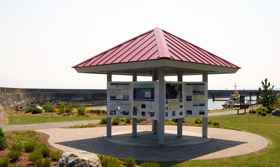
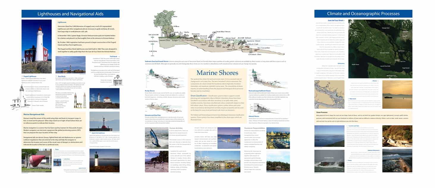
The Interpretive Kiosk
Ogden Point is the home to the Cruise Ship Terminal in Victoria, BC where 500,000 + Visitors disembark annually to visit Victoria. The goal of the OPES was to create a series of interpretive signage which outlined the incredible marine life surrounding the Ogden Point Breakwater and detail the ecological marine and terrestrial topography of the surrounding area and Vancouver Island. The kiosk is located at the entrance to the Ogden Point Breakwater.
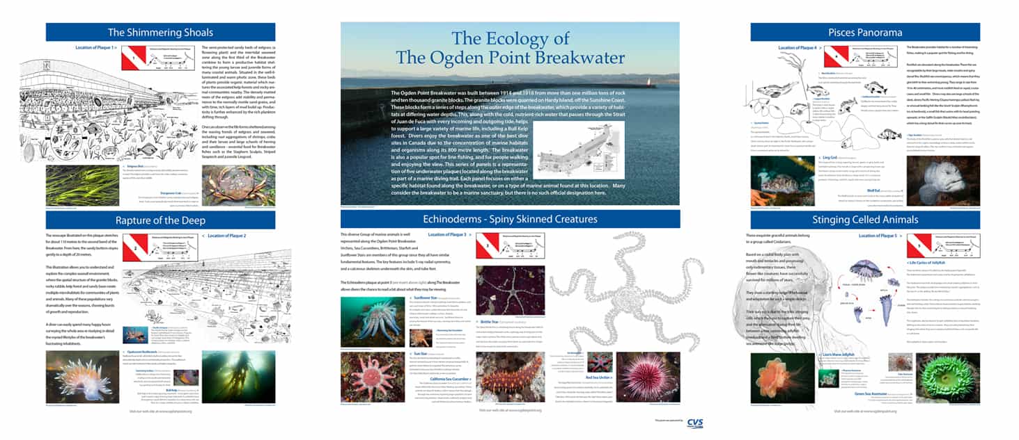
The Ecology of the Ogden Point Breakwater
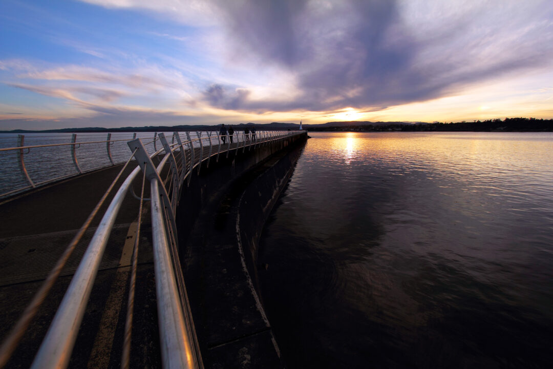
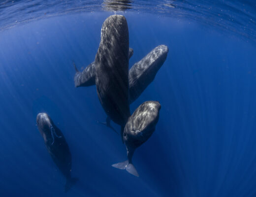
The Ogden Point Breakwater was built between 1914 and 1916 from more than one million tons of rock and ten thousand granite blocks. The granite blocks were quarried on Hardy Island off the Sunshine Coast. These blocks form a series of steps along the outer edge of the breakwater, which provide a variety of habitats at differing water depths. This, along with the cold, nutrient-rich water that passes through the Strait of Juan de Fuca with every incoming and outgoing tide, helps to support a large variety of marine life including a Bull Kelp forest. Divers enjoy the breakwater as one of the best dive sites in Canada due to the concentration of marine habitats and organisms along its 800 metre length. The breakwater is also a popular spot for line fishing, and for people walking and enjoying the view. This series of panels is a representation of five underwater plaques located on the seabed along the breakwater as part of a marine diving trail. Each panel focuses either on a specific habitat found along the breakwater or on a type of marine animal found at this location. Many consider the breakwater to be a marine sanctuary, but it has no official designation.
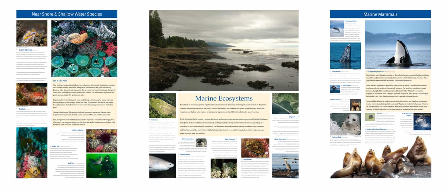
Marine Ecosystems
A multitude of marine ecosystems together characterize the ocean. The ocean is the largest aquatic system on the planet, covering over seventy percent of the Earth’s surface. The habitats that make up this system range from very productive nearshore and shallow water regions to dark abyssal regions more than 4000 metres below the ocean’s surface.
British Columbia’s Pacific coast is a biologically diverse and productive temperate marine environment. Island archipelagos, deep fjords, shallow mudflats and estuaries, kelp and eelgrass beds, strong tidal currents and massive upwellings all contribute to extra-ordinarily high biodiversity. The abundance of coastal marine life not only contributes to the complexity and total biomass of the marine food web but also provides food for terrestrial animals such as otters, eagles, ospreys, bears, raccoons, mink and humans.
Juan de Fuca Strait
Juan de Fuca Strait is a broad channel linking the inner coastal waters of the Strait of Georgia and Puget Sound with the Pacific Ocean. The Strait’s ecosystems are influenced by ocean processes, the bathymetry and climate of the area.
Climate and ocean processes are vital to the survival of marine organisms. Currents and tides transport nutrients, mix oxygen through the water column, help in reproduction by dispersing spores, eggs and larvae, and help in the movement and migration of many marine animals. Upwelling of nutrient rich cold water from the deep ocean to shallow coastal waters replenishes the food available for marine organisms. Plants and animals that are anchored to rocky shorelines depend on currents, both tide and wind fuelled, for all their needs. Kelp beds, for example, exist only where currents or waves supply abundant nutrients and constantly mix the water.
Bathymetry data describes the depths and seabed configuration of bodies of water. Juan de Fuca Strait is about 100 kilometres long and 25 kilometres wide. Its depth ranges from 250 metres at the Pacific Ocean to 55 metres at the sill that separates Juan de Fuca Strait from Haro Strait, which is located approximately 7 kilometres east of Ogden Point.
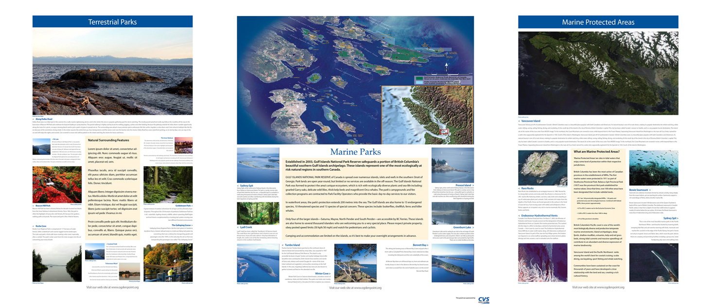
Marine Parks
Marine parks are coastal areas that have been given special designation to conserve marine resources, protect them from development and ensure that the public has ongoing long-term recreational opportunities. Of the marine parks in the Victoria area, the largest and newest is the Gulf Islands National Park Reserve. This park was established to safeguard one of the most ecologically at risk natural regions in southern Canada. When visiting the park, it is important to abide by all of the posted signs and warnings, and to not remove or disturb any of the natural or heritage features.
Gulf Islands National Park Reserve
Established in 2003, the park protects a large portion of British Columbia’s beautiful southern Gulf Islands – a landscape of rocky headlands, forested hills and shores studded with colourful tidal pools. This national treasure resembles a patchwork quilt of protected lands interspersed among farms and residential areas and is scattered over 15 larger islands and many smaller islets and reefs.
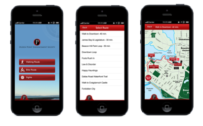
Develop A Walking App
In 2012, the OPES decided to fund and create the first walking App available in the City of Victoria with the goal of allowing cruise ship passengers to download it for free and have the option of taking multiple walks from the cruise ships to downtown Victoria and show multiple walk options and attractions along the way and also provide walk times – an important consideration for visitors on short intervals.
I was tasked in creating it from scratch, which involved bringing a lot of local business on board as waypoints. It was a fun process and was certainly an early model of how an App could work, since I created it in 2012.
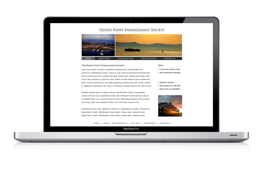
The Initial Website circa 2008
This was a project I deeply wanted to succeed and launched an early simple website to start spreading the message.
The Solution & Result
Over the eight years I sat on the Board of Directors for the Ogden Point Enhancement Society, I developed a brand identity for the Society, conceptualized and developed an Ecological Interpretive Kiosk, built and evolved a highly effective responsive website and developed the first Walking App in Victoria, British Columbia. The Walking App has been downloaded more than 500 times since it’s inception and the website receives in excess of 5,000 visits annually.


No Comments